
Our country is a pioneer in water saving with precision agriculture, all with field meters and with Spanish technology Plantae that we are exporting to other continents, Africa, Asia, America. We have systems to measure water consumption for each crop and type of land. The probes allow for precise measurements in the subsoil.
Water saving
Precision agriculture is basically the control of irrigation water, optimizing the water in the soil with probes adapted to any type of root system and installable in all types of terrain.
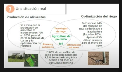
Precision agriculture encompasses everything that allows field measurements: GPS, drones, satellite images, sensors, flow meters, everything so that decisions do not have to be made by eye. What cannot be measured cannot be controlled.
In success cases on water saving that we have already published: olive trees, avocados, stone fruit, tomatoes, apple trees..., we can see real cases of savings of 30% to 50%.
In the Plantae Webinar video, held on January 22, 2025, the graphics of the humidity sensors that indicate this water saving are explained, with control throughout the phenological state of the crop. The graphs are used to make decisions about when and how to irrigate. The humidity of the crop is maintained according to the farmer's decisions.
The sensors consist of two rods adapted to the root system, their depth varies from 10 centimetres to 90, all wireless and controlled by a Hub powered by solar energy or by cable at the farmer's discretion and depending on the size of the farm. They can be visible or buried as is the case on golf courses.
Plantae's team of advisors provides guidance on each crop, but the final decision is made by the farmer, based on the data measured by the sensors.
There are areas controlled by regulations, such as the Mar Menor, but most clients make the decision to control irrigation based on the advice of our advisors.
Another important control is salinity, with conductivity probes.
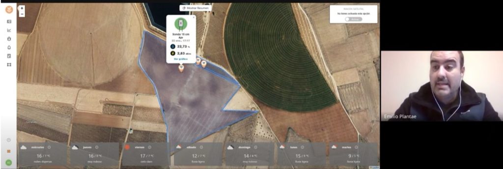
How do we control the sensors?
The plots are displayed with satellite images. As can be seen in the image, the plot is georeferenced from the platform. The area marked in blue is the one we are controlling and by clicking on the icons we can view the installed equipment, its depth and its humidity and electrical conductivity measurements or if it is a flow meter.
Each client sees his/her plot and is always advised so that the interpretation of the data is very simple. We sell service.
Plantae is a leader in helping farmers.
Plantae is a leader in helping farmers
Sources